
You are using an out of date browser. It may not display this or other websites correctly.
You should upgrade or use an alternative browser.
You should upgrade or use an alternative browser.
Challenger crash at Truckee/Tahoe 7/26/21
- Thread starter Jim Carpenter
- Start date
Palmpilot
Superior Pilot
These appear to be the relevant METARs:
KTRK 262050Z AUTO 28011G16KT 04SM BKN023 33/08 A3013 FU RMK VIS 3 1/2/V5 FU BKN023 ACFT MSHP
KTRK 261945Z AUTO 09005KT 04SM BKN023 32/06 A3014 FU RMK VIS 3 1/2/V5 FU BKN023
KTRK 262050Z AUTO 28011G16KT 04SM BKN023 33/08 A3013 FU RMK VIS 3 1/2/V5 FU BKN023 ACFT MSHP
KTRK 261945Z AUTO 09005KT 04SM BKN023 32/06 A3014 FU RMK VIS 3 1/2/V5 FU BKN023
thejanitor
Instrument Training
Low visibility caused accelerated stall?
jhempel
Private Pilot
Something like that would be my guess since everything sounded normal until the crash. Perhaps a too slow and steep of a turn trying to keep the runway in sight. I also wonder about the possibility of a wind shear combined with being too slow. The controller said the winds were calm, but the first METAR posted above doesn't concur.Low visibility caused accelerated stall?
Palmpilot
Superior Pilot
The two METARs bracketing the time of the accident show that the wind picked up a great deal during that hour.
ScottM
In the Clouds
- Joined
- Oct 2, 2019
- Messages
- 4,696
There are indications and reports that visibility was deteriorating and there was a report of "cells" in the areaSomething like that would be my guess since everything sounded normal until the crash. Perhaps a too slow and steep of a turn trying to keep the runway in sight. I also wonder about the possibility of a wind shear combined with being too slow. The controller said the winds were calm, but the first METAR posted above doesn't concur.
ScottM
In the Clouds
- Joined
- Oct 2, 2019
- Messages
- 4,696
They did not do that.Anyone know why they overflew the airport and then did a racetrack back?
N605TR Flight Tracking and History 26-Jul-2021 (KCOE-KTRK) - FlightAware
Track N605TR flight from Coeur D'Alene/Pappy Boyington Fld to Truckee-Tahoe
 flightaware.com
They flew in, got assigned a hold for some reason, as they were making the first circuit on the hold they were cleared for the RANV 20 with circle to land 11. There was no overflight of the Truckee airport on the flight track
Last edited:
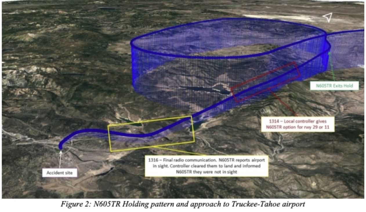
In examining the track plot from FlightAware and the approach chart, it all looks pretty bizarre. The originally crossed the IF (AWEGA) at FL200 (8000 feet higher than called for at that point) and continued south at that altitude almost to the FAF before beginning a descending right turn back to the north working well south of the published MA hold at AWEGA. They flew a descending path north back up to abeam AWEGA, and there began a descending right turn back to join the final approach still about 4000 feet high. Continuing to descend, they passed the FAF about 1200 feet high and the last stepdown about 400 feet with a 2000 ft/min descent rate -- all in all, far from a stabilized approach, and totally contrary to the rules regarding the approach (requiring that they arrive at the IF within 90 degrees of the FAC at the IF altitude).
All pretty ugly.
All pretty ugly.
Palmpilot
Superior Pilot
The first article posted above said the accident occurred shortly after 1:00 PM (2000Z). Aviationweather.gov lists the most recent METARs first. The second one on the list (1945Z) was the one before the accident, and gave the wind as 09005KT, which is not that far from being calm....The controller said the winds were calm, but the first METAR posted above doesn't concur.
Aeromot
Superior Pilot
Lots of detail here:

 www.ainonline.com
Investigators Depart from Fatal Challenger Crash Site | AIN
NTSB was on scene of the crash site near Truckee-Tahoe Airport for five days as they gathered information on a Challenger 605 accident that killed six.
www.ainonline.com
Aeromot
Superior Pilot
It appears that it came pretty close to hitting a school bus, based on this video:
Aeromot
Superior Pilot
This article discusses the NTSB Preliminary:
 www.avweb.com
NTSB Releases Preliminary Report On Truckee Challenger Crash - AVweb
Report shows that the business jet accepted a circling approach after one turn in a holding pattern.
Palmpilot
Superior Pilot
Found it:Doesn't look like the preliminary addresses or even identifies the issues I discussed above in post #11. Anyone got a link to the actual preliminary?
https://data.ntsb.gov/carol-repgen/api/Aviation/ReportMain/GenerateNewestReport/103554/pdf
Here's where I found it:
https://data.ntsb.gov/carol-main-public/basic-search
Aeromot
Superior Pilot
The NTSB has spoken:
www.ainonline.com
NTSB: 'Critical Errors' Caused Fatal Challenger 605 Accident in 2021 | AIN
A July 2021 fatal crash of a Bombardier Challenger 605 in California was due to “the first officer’s improper decision…and the captain’s failure to intervene.”
www.ainonline.com
Aeromot
Superior Pilot
Share: